**This research was first published in the June 19, 2024 edition of the Chatham Star-Tribune newspaper as part of Kyle Griffith’s weekly segment entitled “Heritage Highlights.”
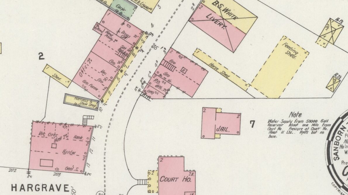
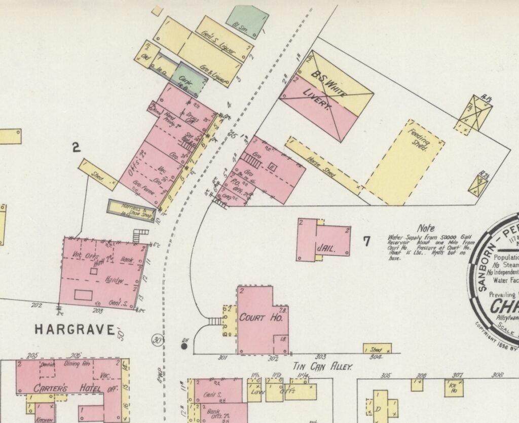
Cropped section of the 1896 Sanborn Map of Chatham
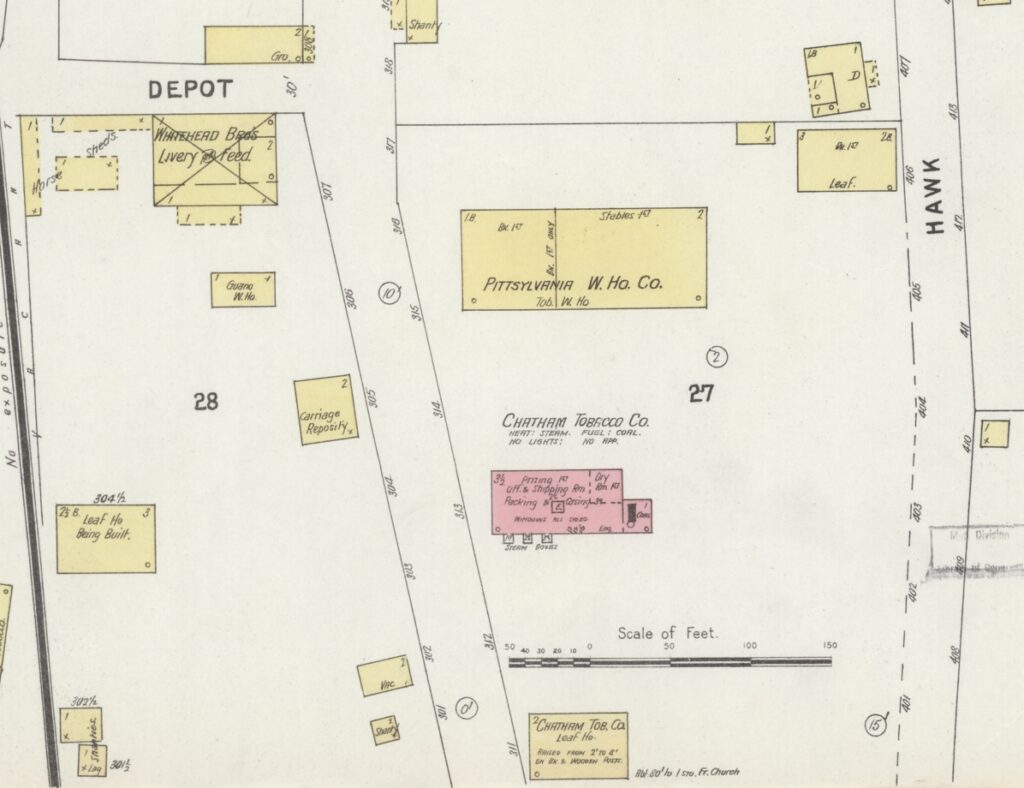
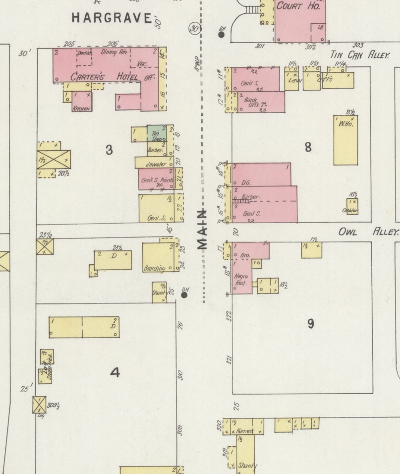
Imagine the scene as a visitor to the Town of Chatham during the 1890s. Main Street remained a rutty dust trail trodden with hooves and wagon wheels. About 850 people populated the town. During those days, trees and foliage still stood along the street and some of the stores sold livestock. Thanks to a Sanborn Fire Insurance map from 1896, it is possible to develop a thorough understanding of the town layout over 125 years ago. As a note pertaining to color coding on the map: yellow structures are frame, red structures are brick, green structures are “specials.”
Beginning at the south end of Chatham town limits, passing by the cemetery, visualize heading north. The first signs of business prevailed in the form of tobacco manufacturers. To the right, Chatham Tobacco Company’s frame “leaf house” was raised on wooden posts. Also their 3 ½ story brick building contained a prizery on the first floor, packing on the second, and a room for casing tobacco on the third floor. This building still exists as Chatham Knitting Mills, Inc. To the north was an even larger frame tobacco warehouse for the Pittsylvania Warehouse Company. Across the road, Whitehead Bros. Livery & Feed was situated on the corner of Depot Street where a parking lot is today. Several outbuildings were present including various horse sheds, a guano warehouse, carriage repository, and a leaf house in construction. Passing by Depot Street, at the present well-landscaped site of Giles Corner stood a store building of equal size. The block, sparsely populated, was home to just one dwelling house and a couple of shanties. Across the street, at the present site of the post office, sat a shanty and harness shop.
Continuing forth, on the right where the old red streetcar restaurant stood, a single-story brick building operated as a grocery store and restaurant for African American community members. Directly across was a two-story frame boarding house with a shanty and a larger dwelling house adjacent. Passing by the present Competition Alley and “Owl Alley,” a two-story brick building was split into a general store and barber shop. Another dry goods store adjoined the northern wall, which remains today as Callands Coffee. The adjacent lot is still empty, but it used to lead to a frame warehouse building set back from the road. The present site of the bank was also a bank in 1896, which was adjoined by a general store on the corner of the block. Across the street, bordering the north side of Competition Alley sat a frame general store, then a brick general store that sold paints. Next, a narrow frame jeweler’s store and adjoined by a building that housed a barber shop and tinsmith’s shop. Beside this strip of businesses sat Carter’s Hotel, one of the early prominent businesses in town. It boasted a large dining room, dentist office, exterior kitchen building, offices, vacant rentable space, and a large stables.
The courthouse, before several additions, was wider than it was long. People called the narrow road traveling beside the courthouse “Tin Can Alley.” The older two-story brick jail building was in about the same location as now, set back from Main Street. Across, in the bend, sat a two-story brick commercial building that contained a general store, hardware store, and bank with offices. Situated in the wedge was a narrow, single-story, iron-clad building that operated as a harness & shoe shop. Adjacent to that was a row of businesses situated in segmented brick buildings that had three grocery stores, one also sold furniture, another room was vacant, then there was a hand printing office adjoined by a drug store. Each had offices on the second floor. The location now contains M&W Flower Shop and the Star-Tribune, which was the last brick building in the row. Adjacent, there was an old iron-clad building set back from the road that operated as a carpentry shop. Beside that were two big frame buildings–a grocery and general store–both of which sold liquors. At the corner of Center Street sat an old single-story building that served as a blacksmith shop. Directly across the road sat B. S. White Livery, a sizable operation with a long horse shed, feeding shed, and a couple outbuildings. At the present site of the Sheriff’s Office sat a short row of two-story brick buildings that included two grocery stores, the post office, and other offices.
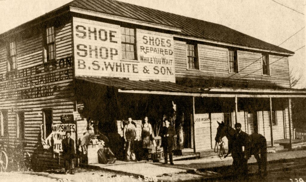
An early 20th century photo of the building owned by B. S. White & Son, which was a shoe shop after it was a livery.
The map from 1896 did not expand further north or south from the locations covered here. Very few of the businesses are identified by name in the map, but are described by function. Thankfully, enough of the buildings still survive to visualize the state of Chatham long ago.

Margaret Gupton
jamie t Seabrooke
Barry Bryant
Kyle Griffith
Kyle Griffith