**This research was first published in the May 15, 2024 edition of the Chatham Star-Tribune newspaper as part of Kyle Griffith’s weekly segment entitled “Heritage Highlights.”
Before the railroad, communities relied on local networks of communication and commerce, often centered around the prominent waterways and country stores. These stores were not just economic centers but also social and cultural landmarks, offering goods, postal services, and serving as a communal gathering space. During the 1830’s, the region produced over six million pounds of tobacco annually, and livestock numbers—19,000 cattle, 19,000 sheep, and 42,000 hogs—surpassed the human population.
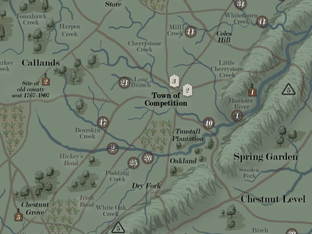
Travel across the Staunton River and the Dan was made possible by numerous ferrying services and fording sites. The roads were wild and unreliable, winding through forests, hills, and meadows. Ward’s Road connected Lynchburg to Danville, while others like Hickey’s Road and Irish Road cut diagonally through the county. Along the way, numerous taverns hosted traveling families for refreshments and lodging, including Beaver’s Tavern near Fall Creek, Davis and Lovell’s Tavern within the town of Competition, and Yates Tavern to the north near modern-day Gretna.
Many of the current communities had not developed and others existed under a different name. For example, the county seat at that time was known as “Pittsylvania Court House” or the Town of Competition (now Chatham). The town had about three hundred residents. The locations of Gretna and Hurt were extensive private tracts in the vicinity of “Ward’s Sulphur Springs.” Danville had not yet developed into a city, but the town still held the largest population of about a thousand people. They had five tobacco warehouses and ten tobacco manufactories The old town of Peytonsburg at the Halifax line had reverted back to an area of sparse settlement after the Revolution. At the far northwest, another town existed under what is now the man made reservoir of Smith Mountain Lake. According to late historian Herman Melton’s research, settler Abner Anthony subdivided more than twenty-five lots on fifty acres to develop a town called Monroe in 1818. However, the community was short-lived and ceased to exist by the mid-nineteenth century.
Following a fire in Washington D.C. In 1837, a directive from the Postmaster General required new postal documentation throughout the county. Ward’s Bridge served as one of the main crossroads between Campbell, Bedford, and Pittsylvania at the Staunton River. Along the Smith and Turkeycock mountain ranges, some of the main post offices were located at Berger’s Store, Craft’s Store (now Redeye), Sandy Level, and Callands. To the northeast, post offices at Edge Hill, Mt. Airy, and Chalk Level were in operation. Offices at Spring Garden, Laurel Grove, and Aspen Grove were formed east of the White Oak Mountain. To the west, Chestnut Grove (now Whitmell) and Sugar Tree were growing communities.
The county contained more than 40 grist mills sites in the 1830’s, many of which were out of operation throughout the decade. Many were forced to close during the Panic of 1837. Some of the notable grist mills in operation included Beaver’s Mill on Banister River, Dove’s Mill on Stinking River, Galveston on Whitethorn Creek, Grubb’s Mill on Bearskin Creek, Cork Mill (Mt. Airy) on Stinking River, Pigg’s Mill on Pudding Creek, Soapstone Mill on the South Prong of Sandy River, and Sutherlin Mill on Double Creek.
The area also had several private schools, known as academies, despite a large unschooled and illiterate population. Academies were located in Danville, east of Chatham, at the Banister River, one at Callands, and a private school for the Muse Family near Pigg River. At Chestnut Grove, “The Academy” served as a predecessor to Whitmell School decades later. Near Straightstone Creek, “Woodbourne Classical School” was attended by students from Pittsylvania and Campbell Counties. Several of the academies hired Joseph P. Godfrey (Abt. 1805-1869) who taught the children of prominent local families.
For historical research, resources lack a detailed selection of pre-railroad maps for the county’s communities, especially anything with colorful illustrations and easily legible text. All of this geographic information is depicted on an 18x24in poster titled “1837 Map of Pittsylvania County, VA” designed by Kyle Griffith. Maps of the same style for other time periods are in development and will be released in the future.

Vicinity of Competition (Chatham) in the 1830s, according to my 1837 map
Vicinity of Danville in the 1830s according to my 1837 map.

